Fascinating video about blue sky ice that does not consist of water. I'm not a huge fan of the ice wall as described in the flat earth circle model, but equally I think there are things in both circle and globe models that the other fails to adequately explain. So generally I find any information on this topic interesting and gives me pause for thought.
Military man speaks about the WALL of Antarctica on Crater Earth not globe
Antarctic oddities, is there a wall?
-
rachel

- Posts: 3872
- Joined: Thu Oct 11, 2018 9:04 pm
- Location: Liverpool, England
- Has thanked: 1362 times
- Been thanked: 1646 times
-
rachel
- Posts: 3872
- Joined: Thu Oct 11, 2018 9:04 pm
- Location: Liverpool, England
- Has thanked: 1362 times
- Been thanked: 1646 times
Re: Antarctic oddities, is there a wall?
Some interesting facts from a Russian site.
https://translated.turbopages.org/proxy ... -mira.html
If it's about safety and protection, it's a deception, isn't it? And something more important than profit? How many rare birds have wind turbines killed? Who in these circles gives a shit about that?
And onto the melting of the ice sheets...
I've got to say, this is a rather curious diagram considering we are apparently talking about an island. It does rather point to something else entirely.
https://translated.turbopages.org/proxy ... -mira.html
Much about Antarctica is still unknown, and it remains the most mysterious and interesting part of the world on Earth.Here are some interesting facts about Antarctica:
- According to the Antarctic Convention, Antarctica does not belong to any country in the world.
- Although there is no population here, the mainland has its own phone code, flag, and user top-level domain.
- In Antarctica, an absolute minimum of cold was recorded: -89 degrees Celsius.
- Antarctica is the fifth largest continent.
- The warmest Antarctic month is February. During this period, there is a change of scientists at the station.
- The Antarctic Weddell Sea is officially considered the cleanest sea in the world.
- The Antarctic Scientist's menu must include beer daily.
- The largest iceberg in history is considered a piece that broke off from the glacier in 1999. Its size was comparable to the area of London.
- There are no surgical procedures performed on the human body, so people who have not had their wisdom teeth and appendix removed are not allowed here.
- The mainland is located in all time zones of the world.
- It has its own bar — it is considered the most inaccessible in the world and is located on the Ukrainian station.
- Argentina drew up and implemented an insidious plan to claim the Antarctic lands: a pregnant woman was sent there, as a result of which a child was born here in 1979, but the Argentines ' plan was not to be realized.
Antarctic Treaty
In previous years, researchers who landed in Antarctica declared this or that area the property of their state. This led to disputes over different territories. In 1959, twelve States signed the Treaty on Antarctica, which defined its status as a continent free from economic and industrial activities. Today, many countries have joined this treaty.
Antarctica is the only continent under joint international management. The Treaty provides for the protection of the Antarctic wildlife. Scientists of one country should share the results of their scientific discoveries with the invited representatives of all countries that have signed this treaty. The only representatives of the army in Antarctica are military personnel involved in scientific research. Snowmobiles are used for transportation in Antarctica.
Mineral resources
Geologists believe that Antarctica has large reserves of coal, iron and copper. The Antarctic Treaty prohibits the exploitation of any minerals, but some countries would like to amend it to allow them to mine them. Many believe that the development of minerals will cause irreparable damage to plants and animals. Airfields and berths will have to be built on the coastal lands. This is where colonies of seals, penguins and seabirds are located.
If it's about safety and protection, it's a deception, isn't it? And something more important than profit? How many rare birds have wind turbines killed? Who in these circles gives a shit about that?
And onto the melting of the ice sheets...
I suspect this is speculation with no evidence in the real world. Because it goes on to say.The Antarctic ice sheet is the largest on our planet and exceeds the nearest Greenland ice sheet in area by about 10 times. It contains ~30 million km3 of ice, or 90 % of all land ice. Due to the weight of the ice, geophysicists ' research shows that the continent has sunk by an average of 0.5 km, which is also indicated by its relatively deep shelf. The ice sheet in Antarctica contains about 80 % of the planet's fresh water; if it completely melts, the level of the world's oceans will rise by almost 60 meters (for comparison, if the Greenland ice sheet melted, the ocean level would rise by only 8 meters).
So how much does the sea rise in the summer, when all those ice sheets shrink? Surely we are all versed in the yearly flooding we experience as a result of parts of Antartica melting? ...No, I don't seem to think so. Instead, could it be because we live in a closed system it makes no odds how much ice melts in the same way a fountain spraying water in a pond never causes that pond to overflow, simply because no new water is ever added.A special feature of Antarctica is the large area of ice shelves (low (blue) areas of West Antarctica), which accounts for ~10 % of the area above sea level; these glaciers are the sources of icebergs of record size, significantly exceeding the size of icebergs of the output glaciers of Greenland; for example, in 2000, the largest known ice shelf broke off from the Ross Glacier. at the moment (2005) iceberg B-15 with an area of over 10 thousand km2. In winter (summer in the Northern Hemisphere), the area of sea ice around Antarctica increases to 18 million km2, and in summer it decreases to 3-4 million km2.
How do we think they are generating electricity in those Antarctic stations?...Remember the curious vertical structures in the background of this 15th century painting? They like their tall objects, don't they.
Vostok station is located in the center of Antarctica at the south geomagnetic pole. Here, a temperature period of -89.20 C is recorded. The polar summer takes place at a temperature of -60 C. Vostok station is located at the very top of the ice dome of Antarctica, the height of which is 3,500 m. Lack of oxygen is felt here, as on the top of Elbrus. The air is 10 times drier than the Sahara Desert. Blood pressure — half below normal.
In the first three days, a person cannot work normally and move quickly, and it is difficult to speak and connect thoughts. Many people experience headaches and vomiting. This changes blood pressure and blood composition. For many years, scientists around the world have been studying the mysteries of Antarctica and its nature. For polar explorers, summer is a time to conquer icy mountains and dive into the depths of the Southern Ocean
I've got to say, this is a rather curious diagram considering we are apparently talking about an island. It does rather point to something else entirely.
-
rachel
- Posts: 3872
- Joined: Thu Oct 11, 2018 9:04 pm
- Location: Liverpool, England
- Has thanked: 1362 times
- Been thanked: 1646 times
Re: Antarctic oddities, is there a wall?
https://rickpotvinflatearth.blogspot.co ... cules.html
Casey to McMurdo via LC130 Hercules travels which way?
Wednesday, May 20, 2015
You can hear someone ask at the end of this video "why's he take off that way"?
ANTARCTICA: Hercules C-130. US-Air Force. McMurdo to Casey Station
WHICH WAY IS HE GOING? (indeed)
The standard map below demonstrates that going to McMurdo from Casey would involve an overland flight. See Casey on the lower right shore and the American McMurdo in the middle of the bottom on the coast of Ross Sea. In the video above, someone voiced concern might have thought the plane should fly INLAND across to McMurdo, the shortest route on the standard island map of Antarctica.
Now lets look at the flat earth model. Casey to McMurdo is still overland. But if the plane was taking off down the runway going toward Mirage-- the next town over-- he'd have to do a 180 to get going on his route back to McMurdo. He would head out over the water and then head back in over Dumon, Scott and then to McMurdo. In the standard map above, he would take off down the runwy toward Mirage, but then bank left towards an inland route. That might be way the female asks where he's going-- he's supposed to be headed inland, not over the water-- the latter being consistent with the flat earth. Whoever said "why's he take off that way?" likely is under the impression that map looks like the above, not the one below.
------------
COMMENTS
What exactly is Mirage, Rick? I can't find it in text anywhere. The reason I ask, Australia uses both McMurdo and another airport which takes large aircraft Wilkins Aerodrome at 66°41'22" S, 111°29'09" E 70km SE of Casey, which would make a lot of sense. Why overfly Wilkins to McMurdo and come back to Casey on a smaller plane? I guess the first arrivals are to get Wilkins Aerodrome ready for the season. [it has been in use since 2008 for scientists not tourists]
http://www.antarctica.gov.au/living-and ... -aerodrome
google location for Wilkins
https://www.google.co.uk/maps/place/66% ... !1s0x0:0x0
http://en.wikipedia.org/wiki/Wilkins_Runway
You can see the [current] flight schedules here
https://secure3.aad.gov.au/public/schedules/flight.cfm
RICK: Mirage is actual Mirnyy, a Russian base, between Casey and Davis. I used the word Mirage because it was easier to remember than "Mirnyy" OR... I couldn't see Mirnyy on a low res map and just used Mirage as a name holder for the moment. Here's a better map with Mirnyy on it.
Thanks Rick. There's a nice archived list of all Antarctic Facilties with co-ordinates and landing information here
http://web.archive.org/web/200702180939 ... facilities
Later caches are dead links.
RICK: Ok I'll try to start a new map and install these locations. I'm currently looking for flight times, milegages and blog experiences on flights between key stations and I'm not finding very much. I've been looking at private yacht trips to see where they go. And I've been trying to accumulate trips to the south pole from various stations-- they say McMurdo is the only station by which you go to the south pole-- and that makes sense on a flat earth--- but I also see solo journeys by one person from Novo which make no sense-- maybe they're hoaxes. Certainly the girl who rode a tricycle to the south pole must be... it's ridiculous but presented as real. I'll make a post on that soon. Your details will help but it's obviously tricky to accumulate the data. Some blogger made a comment that he was surprised how fast the trip was by boat from Britain to Halley which was interesting. I found a Russian station near Casey that went inland quite far-- you saw it-- that was the 'train" convoy pulling supplies and sleds but interestingly they don't have any info on going to the pole from there... which makes sense on flat earth because they would be travelling in the opposite direction on the opposite side. So we're looking at datå that we make inferences from. I looked up routes to the pole from various stations and that's hard too.
-
napoleon
- Posts: 3955
- Joined: Thu Oct 14, 2021 3:23 pm
- Has thanked: 1711 times
- Been thanked: 694 times
Re: Antarctic oddities, is there a wall?
fantastic post doll
Upon his return with the apples, however, Atlas attempted to trick Heracles into carrying the sky permanently by offering to deliver the apples himself, as anyone who purposely took the burden must carry it forever, or until someone else took it away. Heracles, suspecting Atlas did not intend to return, pretended to agree to Atlas's offer, asking only that Atlas take the sky again for a few minutes so Heracles could rearrange his cloak as padding on his shoulders. When Atlas set down the apples and took the heavens upon his shoulders again, Heracles took the apples and ran away.
One of the Twelve Labours of the hero Heracles was to fetch some of the golden apples that grow in Hera's garden, tended by Atlas's reputed daughters, the Hesperides (which were also called the Atlantides), and guarded by the dragon Ladon. Heracles went to Atlas and offered to hold up the heavens while Atlas got the apples from his daughters.[20]
-
napoleon
- Posts: 3955
- Joined: Thu Oct 14, 2021 3:23 pm
- Has thanked: 1711 times
- Been thanked: 694 times
Re: Antarctic oddities, is there a wall?
ADDITIONAL INFO ON THE DOGS USE OVER THE YEARS
Removal of the sledge dogs
Annex II to the Environmental Protocol (Conservation of Antarctic Fauna and Flora) required that dogs were removed from Antarctica by April 1994. This ban was introduced because of concern that dogs might introduce diseases such as canine distemper that might be transferred to seals, and that they could break free and disturb or attack the wildlife. It was also thought to be inconsistent for the Protocol to have strict controls on the introduction of non-native species, but at the same time allow huskies to be bred and used in Antarctica.
Dogs were taken to the Antarctic on the early ‘heroic age’ expeditions at the turn of the 20th Century. They were instrumental in helping the Norwegian explorer Amundsen and his team to be the first to reach the South Pole in 1911. The fact that the Norwegians were good and experienced dog handlers was thought by many experts to be one of the main reasons that they were able to reach the pole before Scott and his team. Since those days, dogs have been used extensively for polar travel and for the support of scientific work. Although dogs were slower than vehicles, they were considered to be safer as they were not so heavy and it was thought that huskies also had an awareness of crevasses.
Huskies in a trace about to pull a sledge during their last season in Antarctica, Reptile Ridge, Adelaide Isalnd.
Huskies in a trace about to pull a sledge during their last season in Antarctica, Reptile Ridge, Adelaide Isalnd.
Sledge dogs were used by BAS in the Antarctic from 1945. The original dogs were imported from the Arctic, from Labrador in Canada and there were small additions in stock from Greenland (1954 and 1961). Careful records were kept of the breeding to avoid producing dogs affected by hereditary disorders. Dogs were also exchanged between bases in Antarctica (eg. Argentinian base, San Martin) in order to maintain genetic diversity. At British stations, dogs were generally fed on seal meat and therefore a certain number of seals were killed each year to support them. The dogs were gradually replaced by mechanised transport during the 60s and 70s and skidoos became the main vehicle for transporting field parties overland.
In the 1980’s and early 1990’s, a small number of dogs were kept at Rothera Research Station for recreational purposes. The dogs were well looked after and gave station personnel the chance to get a feel for what the earlier explorers and scientists would have experienced. The dogs were also considered to be good for morale, which is important in an environment where people are away from home for periods of over two years. There was considerable resistance from station personnel when the legislation for the removal of the dogs was put in place.
The 14 remaining dogs were finally removed from Rothera in February 1994. To mark the end of the era, the dogs spent the last season doing what they did best, pulling a sledge as a working team in support of a surveying project on Alexander Island. When the dogs finally departed Rothera, special husky kennels were built and fitted inside the BAS Dash 7 aircraft for the 5-hour flight to the Falkland Islands. The dogs spent several weeks adapting to the warmer climate and new surroundings, experiencing grass, sheep and children for the first time. They flew from the Falklands to the UK on a special RAF Tristar flight. Once again the dogs received a warm welcome to the UK, this time becoming media stars in all the national papers. Once quarantine was completed the final leg of their journey took them to Quebec in Canada, courtesy of British Airways.
Of the 13 dogs who arrived in Canada, 5 died within the first year due to infection and disease. Unfortunately it was not possible to breed from any of the remaining dogs and the last two died in 2001. Sadly, the end of an era for the British Antarctic husky dogs.
For further information: “Of Dogs and Men: Fifty Years in the Antarctic” Edited by Kevin Walton and Rick Atkinson (1996). Images Publishing (Malvern) Ltd. (ISBN 1 89781755X).
-
rachel
- Posts: 3872
- Joined: Thu Oct 11, 2018 9:04 pm
- Location: Liverpool, England
- Has thanked: 1362 times
- Been thanked: 1646 times
Re: Antarctic oddities, is there a wall?
Saw this link, I like this extract, it could have come out of Today's Daily Mail.
It kind of tells us the Antarctic story was shoehorned into the Hitler narrative so the LIARS could cement that image of Antarctica into the mass psyche. But, when it comes to the maps, I think the institutions were not about to lie by claiming things positively, but like the people of the Bar Association, they are quite happy to lie by omission. The omission taking the form of no colour; that some people might for some reason interpret as snow, but it's actually just white space. And any shape that white space appears to take, well because it's just white space, there is no claim that it bears any relation to the area it apparently represents, that's just the viewers interpretation of the map.
Anyway, here's the video about German UFOs.
Admiral Byrd Planes Crashing Into The Invisible Dome Firmament
I like the idea stated "the adversary was able to fly from Pole to Pole unobstructed". If we can travel East and end up West, there is always a chance we can travel South and end up North. And this is actually the main reason no one is allowed past a certain point south. If a boat was recorded heading to the Antarctic and then suddenly is coming down from Greenland and landing in Scotland, that would destroy the globe model in an instant...And the thing is, if we look at where the British were recorded being in the late 1700s, they might have stumbled upon the land travelling North West of Canada. Then realising what they did, decided to keep it to themselves and pretend they travelled South East.
Historical Map of Australia and New Zealand 1788-1911
I'd never really thought about it before, but looking at New Zealand and the major cities in Australia, which side would it suggest the British boats actually came in from, North West or South East?
https://en.wikipedia.org/wiki/Convicts_in_Australia
It kind of tells us the Antarctic story was shoehorned into the Hitler narrative so the LIARS could cement that image of Antarctica into the mass psyche. But, when it comes to the maps, I think the institutions were not about to lie by claiming things positively, but like the people of the Bar Association, they are quite happy to lie by omission. The omission taking the form of no colour; that some people might for some reason interpret as snow, but it's actually just white space. And any shape that white space appears to take, well because it's just white space, there is no claim that it bears any relation to the area it apparently represents, that's just the viewers interpretation of the map.
Anyway, here's the video about German UFOs.
Admiral Byrd Planes Crashing Into The Invisible Dome Firmament
I like the idea stated "the adversary was able to fly from Pole to Pole unobstructed". If we can travel East and end up West, there is always a chance we can travel South and end up North. And this is actually the main reason no one is allowed past a certain point south. If a boat was recorded heading to the Antarctic and then suddenly is coming down from Greenland and landing in Scotland, that would destroy the globe model in an instant...And the thing is, if we look at where the British were recorded being in the late 1700s, they might have stumbled upon the land travelling North West of Canada. Then realising what they did, decided to keep it to themselves and pretend they travelled South East.
I'd never really thought about it before, but looking at New Zealand and the major cities in Australia, which side would it suggest the British boats actually came in from, North West or South East?
https://en.wikipedia.org/wiki/Convicts_in_Australia
Convicts in Australia
Between 1788 and 1868, about 162,000 convicts were transported from Great Britain and Ireland to various penal colonies in Australia.
The British Government began transporting convicts overseas to American colonies in the early 18th century. When transportation ended with the start of the American Revolution, an alternative site was needed to relieve further overcrowding of British prisons and hulks. Earlier in 1770, James Cook charted and claimed possession of the east coast of Australia for Britain. Seeking to pre-empt the French colonial empire from expanding into the region, Britain chose Australia as the site of a penal colony, and in 1787, the First Fleet of eleven convict ships set sail for Botany Bay, arriving on 20 January 1788 to found Sydney, New South Wales, the first European settlement on the continent. Other penal colonies were later established in Van Diemen's Land (Tasmania) in 1803 and Queensland in 1824. Western Australia – established as Swan River Colony in 1829 – initially was intended solely for free settlers, but commenced receiving convicts in 1850. South Australia and Victoria, established in 1836 and 1850 respectively, officially remained free colonies. However, a population that included thousands of convicts already resided in the area that became known as Victoria.
Penal transportation to Australia peaked in the 1830s and dropped off significantly in the following decade, as protests against the convict system intensified throughout the colonies. In 1868, almost two decades after transportation to the eastern colonies had ceased, the last convict ship arrived in Western Australia.
-
rachel
- Posts: 3872
- Joined: Thu Oct 11, 2018 9:04 pm
- Location: Liverpool, England
- Has thanked: 1362 times
- Been thanked: 1646 times
Re: Antarctic oddities, is there a wall?
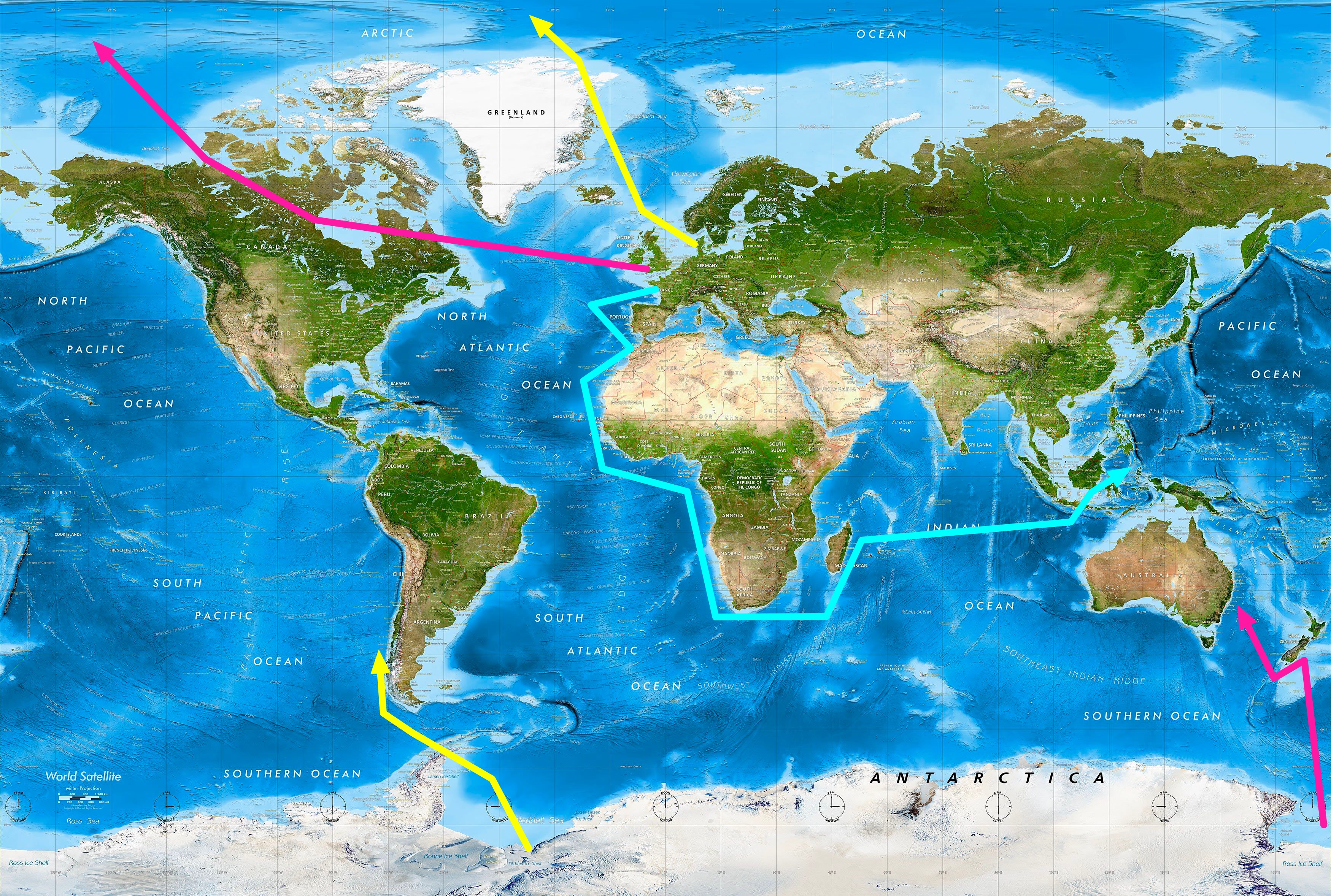
It gets better though when we add in the Danes. i'm not very good at geography and am constantly getting the Scandinavian countries mixed up. But what we can see from this map, Denmark is on a similar Northern latitude to each other, a fair bit further north than say France.
And what that map shows us, Greenland and the Faroe Islands, that blip above Scotland, are both Danish territory, and we know next door to Greenland we have Northern Canada on a similar latitude, British territory.
Now look at the southern map, and which countries hold territory. The pink is Britain, the yellow is Denmark, the light blue is France, the dark blue is China.
Map of the Pacific Ocean 1910
Do you see that? The two countries furthest North hold the most land furthest South. France, less Northernly, hold land more Northernly. What might be a logical reason for this? I don't know, maybe that France travelled South to get to their destination, where as the English and Danish travelled North to get to the same destination; and the journey North, via the territory both countries held North, cut a fair distance off what they actually had to travel compared to France travelling South.
Comparison of world map versus territories held.


And what that map shows us, Greenland and the Faroe Islands, that blip above Scotland, are both Danish territory, and we know next door to Greenland we have Northern Canada on a similar latitude, British territory.
Now look at the southern map, and which countries hold territory. The pink is Britain, the yellow is Denmark, the light blue is France, the dark blue is China.
Do you see that? The two countries furthest North hold the most land furthest South. France, less Northernly, hold land more Northernly. What might be a logical reason for this? I don't know, maybe that France travelled South to get to their destination, where as the English and Danish travelled North to get to the same destination; and the journey North, via the territory both countries held North, cut a fair distance off what they actually had to travel compared to France travelling South.
Comparison of world map versus territories held.
-
rachel
- Posts: 3872
- Joined: Thu Oct 11, 2018 9:04 pm
- Location: Liverpool, England
- Has thanked: 1362 times
- Been thanked: 1646 times
Re: Antarctic oddities, is there a wall?
This is what I'm thinking.
The British expedition would actually set sail from Northern Canada, and the Dutch expedition would actually set sail from Greenland. The French travelling South.
Is there a better explanation for what we see regarding who claimed what, and how they got to be there in the first place?
EDIT: I see my error in mixing up Danish and Dutch on the map. Will address this when I add Norway into the mix in a later post.
-
napoleon
- Posts: 3955
- Joined: Thu Oct 14, 2021 3:23 pm
- Has thanked: 1711 times
- Been thanked: 694 times
Re: Antarctic oddities, is there a wall?
great post rachel
i believe it's flat cos theres no curve ,the wind patterns if they are correct match the flat earth maps of antiquity
as always i do believe with any self evident truth in this day and age they stack the deck in their favour ,by inserting the opposition because even the most feeblest of truther who calls the flat earth a psiop is deluded and ignores the lack of curve . i even invented a word on poncho petes years ago for them ,"curverts",gonna go with my gut instinct